All Rights Reserved@Hangzhou Hyperspectral Imaging Technology Co., Ltd. 浙ICP备19040412号-2 网站地图
Design By: Yushangweb
Water Quality Monitoring

Industry status

Development Goals for China's Water Quality Monitoring Industry During the 14th Five-Year Plan Period
图片3.png


• China possesses total water resources of 2.8124 trillion m³, of which surface water accounts for 96.4%.

• Among the 1,931 surface water quality monitoring sections, the proportion of water quality classified as "Below Grade V" was 3.4%.

• In response to China's water pollution challenges, the government has successively introduced multiple policies and plans to strengthen pollution prevention and control.

• Monitoring is crucial for managing water pollution. Water quality monitoring refers to the process of observing and measuring the types of pollutants in a water body, their concentrations, and trends, thereby assessing the overall water quality status.

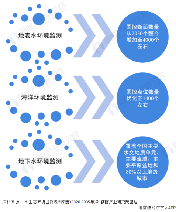
• According to the "Outline of the Ecological and Environmental Monitoring Plan (2020-2035)" issued by the Ministry of Ecology and Environment, between 2020 and 2035, ecological and environmental monitoring will expand from comprehensively deepening ambient quality and pollution source monitoring to gradually incorporating ecological status monitoring and environmental risk early warning, aiming to build a comprehensive assessment system for the ecological environment.


Heat Map of China's Water Quality Monitoring Industry Chain

  • In the realm of surface water environmental monitoring, and in response to the integrated management needs of the "Triad Approach" addressing water pollution control, aquatic ecosystem restoration, and water resource protection, efforts are being coordinated across river basins and regions, water bodies and land areas, and biological communities and their habitats. This comprehensive strategy is facilitating a gradual shift from water quality monitoring towards aquatic ecological monitoring.

  • During the 14th Five-Year Plan period, the number of national monitoring sections was consolidated and increased from 2,050 to approximately 4,000.

  • As China's efforts in water environmental protection and management advance, the market scope for water quality monitoring is concurrently expanding. Based on estimates factoring in the demand for surface water monitoring, groundwater monitoring, and pollution source water quality monitoring, the market size for water quality monitoring in China reached approximately 38 billion RMB in 2020.

图片4.png

564e5d92-ac31-4d7f-8d1d-5f135f1b6eba.png


c35ec801-9469-409d-81b9-4eab0956c8bd.png


Technical Background

Hyperspectral imaging technology, a novel remote sensing technique developed in the early 1980s, organically integrates image morphological measurement with spectroscopic analysis. It represents the future development direction of new detection technologies.


图片1.png

b944e9c1-ce5e-464a-b1bf-136851967419.png


The drone-based hyperspectral water quality monitoring solution serves as a valuable supplement to traditional chemical detection methods. It enables users to grasp the status and trends of the aquatic environment in a timely, accurate, and comprehensive manner.

图片1.png


  • The spectral reflectance of a water body is influenced by dissolved or suspended substances within it. Polluted water, differing from clean water in terms of pollutant concentration and composition, exhibits distinct characteristics in remote sensing imagery, such as variations in texture, grayscale, and reflectance.

  •  Hyperspectral remote sensing enables the monitoring of various water quality parameters through either qualitative identification models or quantitative inversion models.

b2260f07-3d37-43ba-a446-418fe8d75cab.png

图片2.png

Product solution

产品功能特性描述

  1. With a spectral resolution better than 2.8 nm, it enables precise analysis of spectral characteristics of various ground objects.

  2. Features a large-target CMOS hyperspectral camera, supporting up to 1920 spatial channels and 1200 spectral channels.

  3. The onboard control and acquisition system includes a built-in 1 TB SSD, ensuring worry-free data storage.

  4. Hardware-synchronized triggering of a high-definition visible light camera with a resolution of 15 megapixels, supporting high-precision orthophoto mosaic generation.

  5. Incorporates a gimbal self-stabilization system, utilizing UAV push-broom imaging (non-hover scanning) for high operational efficiency.

  6. Deeply compatible with UAV platforms, requiring only a single data cable for connection to provide integrated power supply and data communication; simultaneously acquires GPS information and correlates it line-by-line with hyperspectral data.

  7. Enables remote intelligent control for convenient operation, preventing ineffective flight missions.

  8. Capable of real-time rendering of multi-band spectral composite images, allowing real-time monitoring of hyperspectral acquisition scenes and spectral curves of spatial points.

  9. Pre-loaded with calculations for over 20 common indices (e.g., NDVI), supporting custom band operations and various spectral processing and analysis functions.

  10. Capable of retrieving water quality parameters such as chlorophyll-a, total nitrogen (TN), total phosphorus (TP), ammonia nitrogen (NH3-N), permanganate index (CODMn), and suspended solids (SS).


    图片3.png

                                                                                       HY-9010-L高光谱无人机挂载系统(实物图)


c3b15d41-331f-456f-ab03-155e8e193c65.png

                             高光谱无人机挂载系统


The HY-9010-L Hyperspectral UAV-mounted system utilizes cutting-edge hyperspectral imaging technology to fully exploit the unique spectral signatures of different materials. Integrated with a high-definition camera, it achieves comprehensive detection of qualitative, quantitative, temporal, and locational information, serving as an integrated remote sensing device that combines spectral and spatial data.

This system, which incorporates both a hyperspectral camera and an HD camera, synchronously captures multi-dimensional data during operation. It allows for real-time mission monitoring and remote control. Furthermore, with its built-in high-performance processing unit, the system can perform real-time ground object reflectance calculation and analytical inversion. It is suitable for a wide range of applications, including water environment monitoring, smart agriculture, forestry surveys, target identification, and military camouflage detection, meeting diverse industrial needs.


型号

HY-9010-L高光谱挂载系统

模块

名称

指标

参数

主机 

                       高光谱相机

光谱范围

400-1000nm

光谱分辨率

优于2.8nm

空间分辨率

1.56mrad @f=16mm

视场角

38°@f=16mm

空间通道数

480(4x)

光谱通道数

300(4x)

狭缝宽度

25μm

探测器类型

CMOS

探测器接口

USB 3.0

探测器靶面尺寸

1/1.2”

像素位深

12bits

帧频

50fps

镜头焦距

16mm

高清相机

像素

1500万

控制与采集模块

硬件配置

CPU:I7,内存:16g,硬盘:1TB

GPS定位

支持RTK模式

(需开通相应服务)

定位精度优于250px

其它参数

工作电流

峰值电流:3A

输入电压

13.6V

重量

约3kg

工作温度

0-40°C

储存温度

0-50°C

地面站

地面站参数

工作时间

约4小时

工作电流

峰值电流:1.5A

输入电压

11.1V

重量

约1kg(不含电源)

工作温度

0-40°C

储存温度

0-50°C


image.png

95d5e8f4-7250-4947-9ec5-86447e9659ba.png

The hyperspectral UAV-mounted system features the capability for synchronous multi-dimensional data acquisition. A single flight can capture hyperspectral imagery data across 300 spectral bands along with high-definition visible-light photographs. The accompanying software enables the calculation of various common indices, such as NDVI and NDWI. Furthermore, equipped with built-in multi-parameter water quality inversion algorithms, the system can accurately retrieve key indicators—including Total Nitrogen (TN), Total Phosphorus (TP), Ammonia Nitrogen (NH3-N), Permanganate Index (COD<sub>Mn</sub>), Chlorophyll-a (Chl-a), and Suspended Solids (SS)—and generate clear, intuitive concentration distribution maps to facilitate precise pollution source tracking.


In-flight Inspection Process

image.png

无人机载高光谱监测试飞需求沟通单

试飞需求简述

试飞目的,需求,缘由

试飞地点信息

试飞点地址,百度地图截图,经纬度(如有),监测河道的长度宽度,水深及流速等

试飞区类型

城区/乡村/山区等

地形高程

规划飞行路径需要

当地海拔

无人机飞行一般只能在海拔5000米以下进行飞行任务

期望试飞日期


当地当日天气情况

当前无人机飞行只能在非雨雾雪及4级天气进行。

飞行空域30米距离外

在人口密集区

规划飞行路径需要

飞行空域30米距离外

5层以上高楼是否非常密集

规划飞行路径需要

飞行空域20米距离外

变电所通信基站等

规划飞行路径需要

水质反演等环保水利是否已经有本地的第三方存留数据

各地水质和植物数情况不一样。通过可靠的第三方数据我们能繁衍出来更加精准的当地监测对象数据


Application Cases

 Hyperspectral technology has found considerable application in the monitoring of water body quality. Presently, it permits the quantitative estimation of parameters such as chlorophyll-a concentration, total nitrogen, and total phosphorus, thereby supporting effective water quality evaluation.

dda046da-b498-41cd-9347-ab3899500c0c.png

East China

image.png

Jiangxi Province

image.png

Guangxi Province

image.png

Anhui Province

image.png

Jiangsu Province

image.png

Chongqing Municipality

image.png

message

If you would like to contact us, please fill out the form below so that your inquiry can directly reach the appropriate contact person.
Tel
+86-571-83729176
Phone
15305811932 (Wechat)
Email
sales@hhitgroup.com
Address
Room 503, Building 2, HIAS Sci-Tech Innovation Park, Yunqi Town, Xihu District, Hangzhou, China

All Rights Reserved@Hangzhou Hyperspectral Imaging Technology Co., Ltd. 浙ICP备19040412号-2 网站地图

Design By: Yushangweb